AI for Arctic and Antarctic Discovery (AiCE)  [Fundings and Details]
Automatic Ice Thickness Estimation in Radar Imagery based on Charged Particles Concept
M. Rahnemoonfar, A. Abbassi, J. Paden, G. Fox
Proceedings of IEEE International Geoscience and Remote Sensing Symposium, 2017 [pdf]
Automatic Bedrock and Ice Layer Boundaries Estimation in Radar Imagery based on Level Set Approach
M. Rahnemoonfar, M. Yari, G. Fox, J. Paden
IEEE Transactions on Geoscience and Remote Sensing, 2017 [pdf]
Deep Hybrid Wavelet Networks for Detecting Ice Layers in Radar Images
H. Kamangir, M. Rahnemoonfar, D. Dobbs, J. Paden, G. Fox
Proceedings of the IEEE International Geoscience and Remote Sensing Symposium, 2018 [pdf]
Deep Ice Layer Tracking and Thickness Estimation using Fully Convolutional Networks
Debvrat Varshney, Maryam Rahnemoonfar, Masoud Yari, John Paden
Proceedings of IEEE International Conference on Big Data, 2020 [pdf]
Deep Multi-Scale Learning for Automatic Tracking of Internal Layers of Ice in Radar Data
Maryam Rahnemoonfar, Masoud Yari, John Paden, Lora Koenig, Ibikunle Oluwanisola
Journal of Glaciology, 2020 [pdf]
AI Radar Sensor: Creating Radar Depth Sounder Images based on Generative Adversarial Network
M. Rahnemoonfar, J. Jonson, J. Paden
Sensor, 2019 [pdf]
A Semi-Automatic Approach for Estimating Bedrock and Surface Layers from Multichannel Coherent Radar Depth Sounder Imagery
J. Mitchell, D. Crandall, G. Fox, M. Rahnemoonfar, J. Paden
Proc. SPIE 8892, Image and Signal Processing for Remote Sensing XIX, 2013 [pdf]
Multi-Scale and Temporal Transfer Learning for Automatic Tracking of Internal Ice Layers
Masoud Yari, Maryam Rahnemoonfar, John Paden, L. Koenig, L. Montgomery, I. Oluwanisola
Proceedings of the IEEE International Geoscience and Remote Sensing Symposium, 2020 [pdf]
Smart Tracking of Internal Layers of Ice in Radar Data via Multi-Scale Learning
M. Yari, M. Rahnemoonfar, J. Paden, I. Oluwanisola, L. Koening, L. Montgomery
Proceedings of IEEE International Conference on Big Data, 2019 [pdf]
Radar Sensor Simulation with Generative Adversarial Network
M. Rahnemoonfar, M. Yari, J. Paden
Proceedings of the IEEE International Geoscience and Remote Sensing Symposium, 2020 [pdf]
Image translation between SAR and optical imagery for Arctic wildfire analysis
X. Hu, Maryam Rahnemoonfar, T. Jin
Proceedings of IEEE International Conference on Big Data, 2020 [pdf]
Automatic Polar Ice Thickness Estimation from SAR Imagery
M. Rahnemoonfar, M. Yari, G. Fox
Proc. SPIE 9829, Radar Sensor Technology XX, 2016 [pdf]
Snow Radar Layer Tracking Using Iterative Neural Network Approach
I. Oluwanisola, J. Paden, M. Rahnemoonfar, D. Crandall, M. Yari
Proceedings of the IEEE International Geoscience and Remote Sensing Symposium, 2020 [pdf]

AI for Climate  [Fundings and Details]
Smart Tracking of Internal Layers of Ice in Radar Data via Multi-Scale Learning
M. Yari, M. Rahnemoonfar, J. Paden, I. Oluwanisola, L. Koening, L. Montgomery
Proceedings of IEEE International Conference on Big Data, 2019 [pdf]
Automatic Polar Ice Thickness Estimation from SAR Imagery
M. Rahnemoonfar, M. Yari, G. Fox
Proc. SPIE 9829, Radar Sensor Technology XX, 2016 [pdf]
Deep Ice Layer Tracking and Thickness Estimation using Fully Convolutional Networks
Debvrat Varshney, Maryam Rahnemoonfar, Masoud Yari, John Paden
Proceedings of IEEE International Conference on Big Data, 2020 [pdf]
Deep Multi-Scale Learning for Automatic Tracking of Internal Layers of Ice in Radar Data
Maryam Rahnemoonfar, Masoud Yari, John Paden, Lora Koenig, Ibikunle Oluwanisola
Journal of Glaciology, 2020 [pdf]
Multi-Scale and Temporal Transfer Learning for Automatic Tracking of Internal Ice Layers
Masoud Yari, Maryam Rahnemoonfar, John Paden, L. Koenig, L. Montgomery, I. Oluwanisola
Proceedings of the IEEE International Geoscience and Remote Sensing Symposium, 2020 [pdf]
Determining Displacement and Magnitude of the Bam Earthquake by Envisat Data with InSAR
M. Rahnemoonfar, R. Heidari, M.R. Gheitanchi
Journal of the Earth and Space Physics, 2006
Image translation between SAR and optical imagery for Arctic wildfire analysis
X. Hu, Maryam Rahnemoonfar, T. Jin
Proceedings of IEEE International Conference on Big Data, 2020 [pdf]
Flooded Area Detection from UAV Images based on Densely Connected Recurrent Neural Networks
M. Rahnemoonfar, R. Murphy, M.V. Miquel, D. Dobbs, A. Adams
Proceedings of the IEEE International Geoscience and Remote Sensing Symposium, 2018 [pdf]
Automatic Bedrock and Ice Layer Boundaries Estimation in Radar Imagery based on Level Set Approach
M. Rahnemoonfar, M. Yari, G. Fox, J. Paden
IEEE Transactions on Geoscience and Remote Sensing, 2017 [pdf]
Deep Hybrid Wavelet Networks for Detecting Ice Layers in Radar Images
H. Kamangir, M. Rahnemoonfar, D. Dobbs, J. Paden, G. Fox
Proceedings of the IEEE International Geoscience and Remote Sensing Symposium, 2018 [pdf]
A Semi-Automatic Approach for Estimating Bedrock and Surface Layers from Multichannel Coherent Radar Depth Sounder Imagery
J. Mitchell, D. Crandall, G. Fox, M. Rahnemoonfar, J. Paden
Proc. SPIE 8892, Image and Signal Processing for Remote Sensing XIX, 2013 [pdf]
Earthquake Analysis in Bam (Iran) and Izmit (Turkey) by SAR Interferometry
M. Rahnemoonfar
Conference on Geomatics, Proceedings of National Cartographic Centre (NCC), Iran (May 2005), 2005
AI Radar Sensor: Creating Radar Depth Sounder Images based on Generative Adversarial Network
M. Rahnemoonfar, J. Jonson, J. Paden
Sensor, 2019 [pdf]
Snow Radar Layer Tracking Using Iterative Neural Network Approach
I. Oluwanisola, J. Paden, M. Rahnemoonfar, D. Crandall, M. Yari
Proceedings of the IEEE International Geoscience and Remote Sensing Symposium, 2020 [pdf]
Comprehensive Semantic Segmentation on High Resolution UAV Imagery for Natural Disaster Damage Assessment
Maryam Rahnemoonfar, Tashnim Chowdhury, Robin Murphy, Odair Fernandes
Proceedings of IEEE International Conference on Big Data, 2020 [pdf]
Automatic Ice Thickness Estimation in Radar Imagery based on Charged Particles Concept
M. Rahnemoonfar, A. Abbassi, J. Paden, G. Fox
Proceedings of IEEE International Geoscience and Remote Sensing Symposium, 2017 [pdf]
Radar Sensor Simulation with Generative Adversarial Network
M. Rahnemoonfar, M. Yari, J. Paden
Proceedings of the IEEE International Geoscience and Remote Sensing Symposium, 2020 [pdf]

Deep Perception Beyond Visual Sensors —SAR, SONAR, Thermal, Hyperspectral
Multi-Scale and Temporal Transfer Learning for Automatic Tracking of Internal Ice Layers
Masoud Yari, Maryam Rahnemoonfar, John Paden, L. Koenig, L. Montgomery, I. Oluwanisola
Proceedings of the IEEE International Geoscience and Remote Sensing Symposium, 2020 [pdf]
AI Radar Sensor: Creating Radar Depth Sounder Images based on Generative Adversarial Network
M. Rahnemoonfar, J. Jonson, J. Paden
Sensor, 2019 [pdf]
Automatic Polar Ice Thickness Estimation from SAR Imagery
M. Rahnemoonfar, M. Yari, G. Fox
Proc. SPIE 9829, Radar Sensor Technology XX, 2016 [pdf]
Deep Multi-Scale Learning for Automatic Tracking of Internal Layers of Ice in Radar Data
Maryam Rahnemoonfar, Masoud Yari, John Paden, Lora Koenig, Ibikunle Oluwanisola
Journal of Glaciology, 2020 [pdf]
Deep Hybrid Wavelet Networks for Detecting Ice Layers in Radar Images
H. Kamangir, M. Rahnemoonfar, D. Dobbs, J. Paden, G. Fox
Proceedings of the IEEE International Geoscience and Remote Sensing Symposium, 2018 [pdf]
Deep Ice Layer Tracking and Thickness Estimation using Fully Convolutional Networks
Debvrat Varshney, Maryam Rahnemoonfar, Masoud Yari, John Paden
Proceedings of IEEE International Conference on Big Data, 2020 [pdf]
The First Automatic Method for Mapping the Pothole in Seagrass
M. Rahnemoonfar, M. Yari, A. Rahman, R. Kline
2017 IEEE Conference on Computer Vision and Pattern Recognition Workshops (CVPRW), 2017 [pdf]
Image translation between SAR and optical imagery for Arctic wildfire analysis
X. Hu, Maryam Rahnemoonfar, T. Jin
Proceedings of IEEE International Conference on Big Data, 2020 [pdf]
Determining Displacement and Magnitude of the Bam Earthquake by Envisat Data with InSAR
M. Rahnemoonfar, R. Heidari, M.R. Gheitanchi
Journal of the Earth and Space Physics, 2006
Smart Tracking of Internal Layers of Ice in Radar Data via Multi-Scale Learning
M. Yari, M. Rahnemoonfar, J. Paden, I. Oluwanisola, L. Koening, L. Montgomery
Proceedings of IEEE International Conference on Big Data, 2019 [pdf]
Real-Time Scene Understanding of Unmanned Aerial Vehicle Imagery with and beyond Visual Sensors with Deep Learning
M. Rahnemoonfar, C. Sheppard, D. Bridges
AUVSI's XPONENTIAL Proceedings, 2017 [pdf]
Semantic Segmentation of Underwater Sonar Imagery with Deep Learning
M. Rahnemoonfar, D. Dobbs
Proceedings of the IEEE International Geoscience and Remote Sensing Symposium, 2019 [pdf]
Improved Locally Linear Embedding for Big-Data Classification
A. Ramirez, M. Rahnemoonfar
Proceedings of 6th ACM SIGSPATIAL International Workshop on Analytics for Big Geospatial Data, 2017 [pdf]
Two Dimensional Phase Unwrapping of Interferometric SAR Data by Means of Wavelet Technique
M. Rahnemoonfar, M. Rahmati, M.R. Saradjian, A. Tavakoli
Proceedings of International Geoscience and Remote Sensing Symposium (IGARSS), IEEE Press, 2005 [pdf]
Automatic Oil Spill Detection o Quad Polarimetric UAVSAR Imagery
M. Rahnemoonfar, S. Dhakal
Proc. SPIE 9853, Polarization: Measurement, Analysis, and Remote Sensing XII, 2016 [pdf]
Automatic Seagrass Pattern Identification on Sonar Images
M. Rahnemoonfar, F. Rahman
Proc. SPIE 9844, Automatic Target Recognition XXVI, 2016 [pdf]
Earthquake Analysis in Bam (Iran) and Izmit (Turkey) by SAR Interferometry
M. Rahnemoonfar
Conference on Geomatics, Proceedings of National Cartographic Centre (NCC), Iran (May 2005), 2005
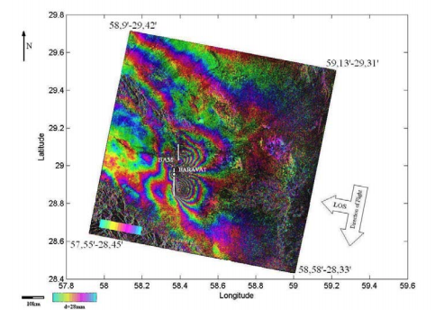
Synthetic Aperture Radar Interferometry Technique for the Evaluation of Earthquake Damages to Historical Structures
M.M. Hejazi, M. Rahnemoonfar
International Course on Architectural and Structural Design of Masonry, Dresden, Germany (December 2003), 2003
Automatic Seagrass Dsturbance Pattern Identification on Sonar Images
M. Rahnemoonfar, A. Rahman, R. Kline, A. Greene
IEEE Journal of Oceanic Engineering, 2018 [pdf]
DEM Generation with SAR Interferometry based on Weighted Wavelet Phase Unwrapping
M. Rahnemoonfar, B. Plale
4th IEEE Conference on Computing for Geospatial Research and Applications, 2013 [pdf]
Snow Radar Layer Tracking Using Iterative Neural Network Approach
I. Oluwanisola, J. Paden, M. Rahnemoonfar, D. Crandall, M. Yari
Proceedings of the IEEE International Geoscience and Remote Sensing Symposium, 2020 [pdf]
Automatic Ice Thickness Estimation in Radar Imagery based on Charged Particles Concept
M. Rahnemoonfar, A. Abbassi, J. Paden, G. Fox
Proceedings of IEEE International Geoscience and Remote Sensing Symposium, 2017 [pdf]
A Semi-Automatic Approach for Estimating Bedrock and Surface Layers from Multichannel Coherent Radar Depth Sounder Imagery
J. Mitchell, D. Crandall, G. Fox, M. Rahnemoonfar, J. Paden
Proc. SPIE 8892, Image and Signal Processing for Remote Sensing XIX, 2013 [pdf]

AI for Autonomous Vehicles  [Fundings and Details]
VIRTUALOT - Combining UAS Products and Computer Vision Techniques to Extend GIS Capabilities
B. Koskowich, M. Rahnemoonfar, M. Starek
Proceedings of the IEEE International Geoscience and Remote Sensing Symposium, 2018 [pdf]
Real-time Scene Understanding for UAV Imagery based on Deep Convolutional Neural Networks
M. Rahnemoonfar, C. Sheppard
Proceedings of IEEE International Geoscience and Remote Sensing Symposium, 2017 [pdf]
Real-Time Scene Understanding of Unmanned Aerial Vehicle Imagery with and beyond Visual Sensors with Deep Learning
M. Rahnemoonfar, C. Sheppard, D. Bridges
AUVSI's XPONENTIAL Proceedings, 2017 [pdf]
Flooded Area Detection from UAV Images based on Densely Connected Recurrent Neural Networks
M. Rahnemoonfar, R. Murphy, M.V. Miquel, D. Dobbs, A. Adams
Proceedings of the IEEE International Geoscience and Remote Sensing Symposium, 2018 [pdf]
Comprehensive Semantic Segmentation on High Resolution UAV Imagery for Natural Disaster Damage Assessment
Maryam Rahnemoonfar, Tashnim Chowdhury, Robin Murphy, Odair Fernandes
Proceedings of IEEE International Conference on Big Data, 2020 [pdf]

Precision Agriculture
Deep Count: Fruit Counting based on Deep Simulated Learning
M. Rahnemoonfar, C. Sheppard
Sensors, 2017 [pdf]
Surveying Phenological Characteristic of Quercus Infectoria outside of Zagross Region for Introducing and Creating Diversity in Urban Green Space
A. Shahbazi, H. Matinkhah, M. Rahnemoonfar
Journal of Natural Environment, 2013
DisCount-Net: Discriminating and Counting Network for Real-Time Counting and Localization of Sparse Objects in High Resolution UAV Imagery
M. Rahnemoonfar, D. Dobbs, M. Yari, M. Starek
Remote Sensing, 2019 [pdf]
Real-Time Yield Estimation based on Deep Learning
M. Rahnemoonfar, C. Sheppard
Proc. SPIE 10218, Autonomous Air and Ground Sensing Systems for Agricultural Optimization and Phenotyping II, 2017 [pdf]

Document Image Analysis
Restoration of Arbitrarily Warped Historical Document Images using Flow Lines
M. Rahnemoonfar, A. Antonacopoulos
Proceedings of the 11th International Conference on Document Analysis and Recognition (ICDAR2011), Beijing, China (September 2011), 2011 [pdf]
Automatic Performance Evaluation of Dewarping Methods in Large Scale Digitization of Historical Documents
M. Rahnemoonfar, B. Plale
Joint IEEE/ACM Conference on Digital Libraries, 2013 [pdf]
A Novel Geometric Pattern Extraction by Means of a Level-Set Method
M. Rahnemoonfar, A. Asefpour
Bridges 2012, Maryland, USA (July 2012), 2012 [pdf]
Mobile-Based Text Recognition from Water Quality Devices
S. Dhakal, M. Rahnemoonfar
Proc. SPIE 9411, Mobile Devices and Multimedia: Enabling Technologies, Algorithms, and Applications, 2015 [pdf]

AI for Health
Fluorescence Microscopy Image Segmentation based on Graph and Fuzzy Methods: a Comparison with Ensemble Method
M. Beheshti, A. Ashapure, M. Rahnemoonfar, J. Faichney
Journal of Intelligent and Fuzzy Systems, 2018 [pdf]
Spatio-Temporal Convolutional Neural Network for Elderly Fall Detection in Depth Video Cameras
M. Rahnemoonfar, H. Alkittawi
Proceedings of IEEE International Conference on Big Data, 2018 [pdf]
Copyright © 2021 Bina Lab, UMBC